
Triple C - Permafrost Region Drained Lake Basins
Understanding causes and consequences of catastrophic permafrost region lake drainage in an evolving arctic system

Understanding causes and consequences of catastrophic permafrost region lake drainage in an evolving arctic system
Linkages among proposed study components (see initial conceptual model), which includes three primary scales of study (landscape, chronosequences, and expected responses sites) and four generalized study methodologies (remote sensing, field studies, modeling, and synthesis). Landscape scale represents the initial stage where lakes susceptible to drainage will be identified and all DTLBs will be mapped and age-classified following remote sensing methods for each of five study regions. High-resolution LiDAR mapping and intensive monitoring and field studies of these basins will be used to examine lake drainage mechanisms, refine the initial DTLB classification, and quantify basin permafrost, vegetation, and hydrologic processes.
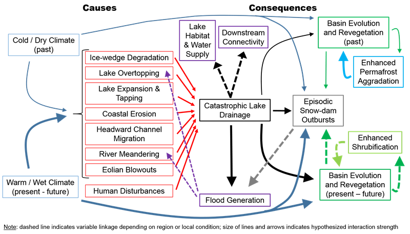
Expected Response Sites will consist of thermokarst lakes with high drainage potential and DTLBs with high snow-dam outburst potential; four of each will be selected per each of five study region. Each of these basins and downstream fluvial systems will be instrumented to record water levels over the three-year study period in order to capture potential flood events and downstream impacts. One of these ERS thermokarst lake sites will be identified in year 1 as the candidate for a lake drainage experiment to capture the downstream flood event, with additional instrumentation in the basin and associated channel system. Data collected from both chronosequence and ERS basins will be used to develop, calibrate, and validate models to simulate scenarios of snow capture and melt, outburst events and downstream flooding. Modeling scenarios of hydroclimate change using WRF simulation output will be used test hypotheses, evaluate responses to forcings, and make predictions—all of which will feed into the development of a refined conceptual model of basin evolution and hydrologic responses with changing climate at the landscape scale. This conceptual model will serve as our primary synthesis product and will provide the theoretical complement to a GIS-based decision support tool intended for application to resource management needs and the broader scientific community.